Three-dimensional coordinate system
Sometime in the early 19th century the third dimension of measurement was
added, using the z-axis.

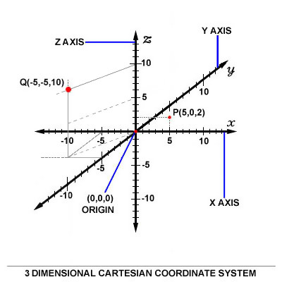
The coordinates in a three-dimensional system are of the form (x,y,z). An
example of two points plotted in this system are in the picture above, points
P(5, 0, 2) and Q(-5, -5, 10). Notice that the axes are depicted in a
world-coordinates orientation with the z-axis pointing up.
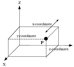
The x, y, and z coordinates of a point (say P) can also be taken as the
distances from the yz-plane, xz-plane, and xy-plane respectively. The figure
below shows the distances of point P from the planes.

The xy-, yz-, and xz-planes divide the three-dimensional space into eight
subdivisions known as octants. While conventions have been established for the
labeling of the four quadrants of the x'-y plane, only the first octant of three
dimensional space is labeled. It contains all of the points whose x, y, and
z
coordinates are positive. That is, no point in the first octant has a negative
coordinate. The three dimensional coordinate system is provides the physical
dimensions of space � height, width, and length, and this is often referred to
as "the three dimensions". It is important to note that a dimension is simply a
measure of something, and that, for each class of features to be measured,
another dimension can be added. Attachment to visualizing the dimensions
precludes understanding the many different dimensions that can be measured
(time, mass, color, cost, etc.). It is the powerful insight of Descartes that
allows us to manipulate multi-dimensional object algebraically, avoiding compass
and protractor for analyzing in more than three dimensions.
Orientation and "handedness"
The three-dimensional Cartesian coordinate system presents a problem. Once
the x- and y-axes are specified, they determine the line along which the
z-axis
should lie, but there are two possible directions on this line. The two possible
coordinate systems which result are called 'right-handed' and 'left-handed'.
The origin of these names is a trick called the right-hand rule (and the
corresponding left-hand rule). If the forefinger of the right hand is pointed
forward, the middle finger bent inward at a right angle to it, and the thumb
placed a right angle to both, the three fingers indicate the relative directions
of the x-, y-, and z-axes respectively in a right-handed system. Conversely, if
the same is done with the left hand, a left-handed system results.
The right-handed system is universally accepted in the physical sciences, but
the left-handed is also still in use.

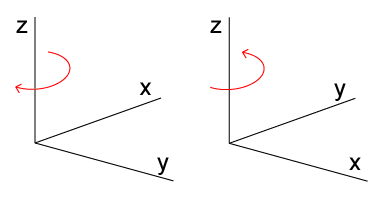
The left-handed orientation is shown on the left, and the right-handed on the
right.
If a point plotted with some coordinates in a right-handed system is
replotted with the same coordinates in a left-handed system, the new point is
the mirror image of the old point about the xy-plane.
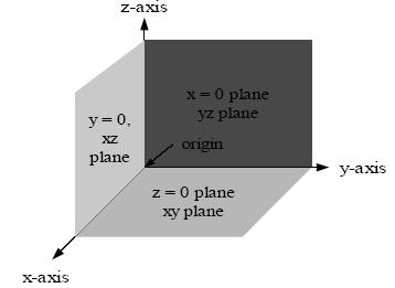
The right-handed Cartesian coordinate system indicating the coordinate
planes.

More ambiguity occurs when a three-dimensional coordinate system must be
drawn on a two-dimensional page. Sometimes the z-axis is drawn diagonally, so
that it seems to point out of the page. Sometimes it is drawn vertically, as in
the above image (this is called a world coordinates orientation).
See also